


Zevtt - St Cyr

kipoura
Gebruiker

Lengte
51 km

Max. hoogte
143 m

Positief hoogteverschil
806 m
Km-Effort
61 km

Min. hoogte
55 m

Negatief hoogteverschil
806 m
Boucle
Ja
Datum van aanmaak :
2019-05-03 17:10:53.687
Laatste wijziging :
2019-05-03 17:10:53.782
3h30
Moeilijkheid : Medium

Gratisgps-wandelapplicatie
 SityTrail
IGN / Geografische instituten
SityTrail Plus
De wereld gaat voor u open
Over ons
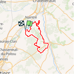
Tocht Mountainbike van 51 km beschikbaar op Nieuw-Aquitanië, Vienne, Beaumont Saint-Cyr. Deze tocht wordt voorgesteld door kipoura.
Beschrijving
Une boucle VTT au départ du plan d'eau de St Cyr, si je ne m'abuse on commence par une grimpette bien harde .... http://zevtt.free.fr
Plaatsbepaling
Land:
France
Regio :
Nieuw-Aquitanië
Departement/Provincie :
Vienne
Gemeente :
Beaumont Saint-Cyr
Locatie:
Saint-Cyr
Vertrek:(Dec)
Vertrek:(UTM)
305644 ; 5177411 (31T) N.
Opmerkingen